February 19-23, 2025
Another route I had in the backlog for several years. I mentioned
here
that I would take a break from Death Valley and head to the Mojave National Preserve. This is that trip.
Kurstin
(@bikepackingnv) and I originally had this trip slated for early February
but didn’t get to it until after mid month. We chose fat bikes because of
the amount of sand we expected to encounter. Be sure to check out the map
link at the bottom to see why the route is called the Mojave Butterfly!
It’s long drive from Carson Valley to the start of the route so
we planned to drive then camp overnight before starting the route in the
morning.

The days ride started at Hole In The Wall visitor center and would take us
along the Mid Hills and through the New York mountains past a number of
points of interest to stop and check out. Government Well (aka Government
Holes), a mine adit noted on the USGS map as being a cave, Lecyr Well and
the
Bert Smith House. All the wells and springs we encountered today were currently dry with
the exception of a well, not far from our start that was pumping water. I
don’t know but I’m surmising that it may be the source of water for the
visitor center? It had a pvc pipe that ran above and below ground that
direction. Also, the fact that at Government Well the pump rods are in place
and the windmill is chained and locked to prevent rotation leads me to
believe that perhaps at certain times of year this well may also be active.

|
|
This well was pumping water.
|

|
| Mine Adit |

|
| Government Well |

|
|
Kurstin at Government Well
|
The Mid Hills and New York’s seem to be mostly a granitic range and therefore
much of the terrain was reminiscent of Joshua Tree National Park.
We also passed through the burn scar from the 2023 York fire. Later on day
3 we passed through the 2020 Dome fire scars. It was sad seeing the
devastation caused to the Joshua Tree forest. But life finds a way and not
only were there some trees surviving but at the end of the trip when we
talked to the folks in the visitor center, Kurstin asked about how long
would it take for the Joshua's to come back. They pointed out that there
were already signs of regenerative growth.
Somewhere late in the day we ran into a caravan of off road vans. Eventually
it was revealed that the lead driver was the ‘Real Chris King,’ maker of high
end bicycle components. We ran into him again on day 3 and it was mentioned he
had been out for 3 months. (Insert jealous
emoji.) We ended the day part way down Ivanpah road overlooking Ivanpah Valley
and Sauron’s (Eye Of Mordor's) kids, the Ivanpah solar generating station. It
was really interesting watching the transition of the super bright 'eyes' on
top of the 3 towers and the mirror fields slowly fade to be replaced by the
normal industrial lighting of the plant. I also realize that in my last few
ride reports I’ve been neglecting to report on the
OTAF. So I’m happy to confirm that the OTAF was negligible this night. HOWEVER,
the DVTAF (Down Valley Train Annoyance Factor) was about 5-6. We camped above
the valley floor for this reason. Would have rattled my fillings if we camped
in the valley bottom.

|
|
Bert Smith House aka 'Rock House'
|

|
|
Rock Spring area. No water found
|

|
| Lecyr Well |

|
| Sauron's offspring in the distance |

|
| PC Kurstin |
On day 2 as the sun rose over the horizon and Sauron’s children awoke, the
day’s ride began with a fast downhill to the valley bottom.
Then a rough but quite passable 4x4 road paralleling the RR track for about
13 miles. No trains came by, they must all be night trains...bada
bing!

|
| PC Kurstin |
In due course we made it to Cima. Nothing there but a train track maintenance
staging area and maybe caretakers residence? Anyway a residence of some sort.
Here we picked up pavement and with the new tailwind we were enjoying we
barely touched our pedals for the gentle 20 mile downhill into Kelso.
Interesting info about Kelso Depot.
We lounged around the old train station, now a visitor center for the park
but closed for renovation, taking pictures and trying to convince the tourists
we weren’t on E-Bikes. Kurstin said we should get T-shirts made that list the
top 10 questions we get on our 'E-Bikes' HAHA! Great idea! Thankfully the
drinking water station was on and we happily filled our bottles with the last
sure water for the next 2 ½ days. Then began the long sandy slow 12 mile climb
up to the Mojave Road as a train finally came rumbling by the old
station.

Remember that wonderful tailwind I mentioned? Yeah, well me neither as all I
remember is a headwind climbing out of Kelso. It was here, about ¾ of the way
up that we met and chatted with
@theforrestbiome, another
Bikepacking Roots
regional steward and creator of such routes as
Capes Of The Canyon,
Gold To Grand, El Lobo Lupus and House Rock Wrap. Check out his IG! He was riding the ‘Mojave Solitaire’. A recently published route on
Bikepacking.com. We
talked for awhile and got some selfies (courtesy of Forrest’s ape index) then
moved on another few miles making camp at the junction with the old
Mojave Road.

|
|
Kurstin getting some too. Don't want to get on the wrong side of
Joannie!
|

|
|
Camp at the junction of the Mojave road
|
Morning of day 3 and we’re checking out Marl Spring. There’s a trickle of
water emerging from the pipe. I’m feeling genius! I brought my dip n’ sip
(name coined by Kurstin) bottle for just such a circumstance! It’s my
hydrapak bottle and filter combination. I used it as part of my overall
water supply but can now filter a bit of additional water.
Onward. We gotta check the mail! Almost unbelievably Chris King and his crew
were camped by the
Mojave Mailbox. Well maybe not so unbelievably since we saw them drive by our camp the
previous evening. We signed in the mailbox register and chatted for awhile
again. I was eyeballing the Fireball shot but I feared for my karma so left it
there for someone who needed it more than I.
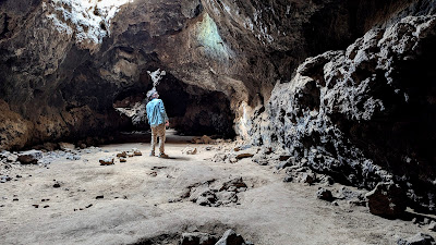
Next stop was the Mojave Lava Tube. We were in the Cinder Cone Lava Beds
and the landscape had switched to volcanic lava fields. As we visited the
tube we were alone. A very interesting site and one I recommend you visit!
Lord of the Ring’s came back into my head as we explored the underground
reaches of the tube. It wasn’t complete darkness as there are a number of
‘skylight’ openings overhead but a headlamp is highly recommended.

|
|
Solidified molten lava drips
|
Pushing on we had the only steep climb of the route climbing up into the
Aiken crater and mine. It was rideable but my back tire spun out in the
loose cinder causing me to walk 50 ft feet. Yeah, that was it.
Leaving Aiken Mine via Black Tank Wash, we were soon out of the lava fields
and back in the ‘normal’ sand climbing up Cima Dome. We ran into a group of
off road trucks. The lead truck stopped us and informed us that there were
four more trucks coming but that they had had some sort of mechanical. He
was trying to be courteous and said we should wait for them so they wouldn’t
“come around a blind corner and hit us.” Huh? That immediately got my hackles
up. I asked if they were hauling ass or what and he replied “usually.” So he
wanted us to wait indefinitely for his crew of 400HP trucks so they could
drive recklessly on backcountry roads open to all. He really was being
polite but I just wasn’t having having it. I thanked him, told him we’d be
careful and we left. Sorry but it just irritated me. 10 or 15 minutes later
they showed and slowed and were very courteous while passing us. My initial
irritation melted away. More long slow washboarded sand took us through the
Dome Fire scar and out to the pavement at Cima Road.

|
| Healthy |

|
| Not so much |
I was feeling kind of beat up from all the washboard of the last 3 days and
wasn’t disappointed to be on pavement. We climbed a bit to the Mojave Cross, a
memorial to all who lost their lives in all wars.

|
| PC Kurstin |
|
Another 6 mile gentle downhill returned us to Cima followed by yet another
trip down Kelso Cima road but this time only as far as our cut off back to The
Hole In The Wall visitor center using Macedonia Canyon road. We rode up about
a half mile and called it for the day. Being that close to the train tracks raised DVTAF to about 7.
Early to bed, early to rise makes a person… not ache so bad for laying in bed
too long. Short day today. Up Macedonia Canyon past some old ruins until the
intersection of Wildhorse road. A little less than 6 miles and 1850 ft climb.
Then it was all downhill through the wildly scenic Wildhorse Canyon and past
some petroglyphs back to Hole In The Wall visitor Center where we
parked.

|
|
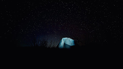
There's something magical about waking up in the desert.
|

|
| PC Kurstin |
Highlights of the trip for me were the wide array of cactus, the Lava Tube,
petroglyphs and very different landscapes from that of Northern Nevada. It was
100% rideable which makes me question whether it was really even a legit
bikepacking trip. There was more pavement than I generally like but traffic
was pretty light. Train noise was a bit unique and I personally enjoyed seeing
the trains go by.
Stats: 145 miles and 10,200 ft of climbing over 3.5 days.
Bikes & water:
Doug -
Binary Bicycles
Gordita semi-custom fat bike full rigid running 26x4.3 fat tires. Full
bikepacking bags. Carried 7 ltrs water with top off fill at Kelso and
additional ~1 ltr filter at Marl Sprg. I had about a ltr left at the end.
Kurstin - Meriwether custom long tail fat bike full rigid running
26x4.8 tires. Full bikepacking bags. Carried 7 ltrs, 8 ltrs after Kelso with 1 ltr refill at Marl Sprg. Kurstin also had roughly 1 ltr of water left.