January 2018 Posted by Doug.
Imagine if you will:
You’re 70 miles from anywhere, 70 miles to anywhere else, monotonously spinning your cranks round and round. It’s hot, it’s uphill, you’re sweaty, you’re thinking “damn, a cold one would sure be nice right about now.” Ahead, through the shimmering heat waves you spy a dust trail. It grows in size and soon you hear the crunch of tires on gravel. You pull over as a white jeep comes into view and slows. You’re not paying close attention to the driver but as the jeep stops alongside, your jaw drops and you do a double take! It’s your very own wife waving a cold beer at you!!! Wait...there's a sign post up ahead, welcome to The Twilight Zone.
Jan 2018
The gnats were ferocious at Ballarat, the jumping off place for this point to point ride. Why? I'm not sure but it definitely hastened the packing of my bike. With a final wave to Joannie I mounted up and rolled away from the camper. My route ran south for 15 miles along the base of the Panamint Range before climbing up Goler Wash and over Mengel Pass. I had ambitious visions of getting up over the pass the first day. Ultimately they were just that. Visions. Rolling south on the graded road I made good time all the way to (I think the name was) DV Resources mine. After that the road deteriorated a bit with some washboard but still not bad. The apparent abundance of water meant lots of wild burros. I saw quite a few along the way. I climbed up the alluvial fan to Goler Wash seeking the shade the narrow mouth of the canyon afforded. Upon reaching it, surprisingly there was water flowing down the middle of the wash. A good omen for finding water in the springs higher up. The climb up Goler was awesome with narrow canyon walls down low and some technical rock steps I had to push with my fully loaded bike. Higher, signs of Death Valley's past came into view with old mining relics including overhead tram cables, ruined cabin walls and rusting machinery. I paused again in some shade and chatted briefly with a nice couple in their 4x4 truck who were interested in my seemingly nutty pedal powered trip up the canyon. I met a couple of other 4x4'ers and all were smiling hugely and giving me thumbs up for my efforts. Eventually it was time to find a place to camp and I found a nice spot well off the road and about 100 yards from a perfect spring where I could filter water in the morning. Unfortunately for a Burro, I had apparently camped in his site. He stood at the top of the ridge above camp braying angrily at me and stomping in a circle above my camp. I told him there were many other trails down off the ridge top but he didn't care. He wanted to use THAT one. After about 10 minutes of yelling at me and stomping his displeasure he finally wandered off the backside out of sight. I half expected to hear the burros all night around the spring but only heard them in the early morning.


I had banked my water needs on finding water at Anvil spring just below the Geologist's cabin in Butte Valley on the other side of the pass, but I've learned to never pass up a water source in the desert. So in the morning I topped off my 9 liters of water and set off toward the pass. I still had about 3 miles before topping the pass. The road continued to be very rideable and I only had to push a couple of short steep and rough sections. Along the way I passed the turnoff to the remains of the Barker Ranch, notorious from when the Manson clan lived there. It was burnt to the ground many years ago and I elected not to detour up to it. Eventually I made it to the top of Mengel Pass. The pass is named for Carl Mengel who lived and mined just a short distance down the road in Butte Valley. At the top is a memorial to Carl and his ashes are interred there. I made my way down from the pass and some pretty gnarly road caused me to walk a short section. Then it was up and down over to the Geologist cabin and Anvil spring. The cabin is well maintained and the tradition is for those using the cabin to clean and try to leave it better than they found it. It appears to be working. There are many historical references about the cabin online so I won't repeat it all here, but this is a good starting point. It was a beautiful place for a break and though a bit early I decided to eat lunch and enjoy the view. I had plenty of water for the remainder of my route so didn't go down to the spring (which was running) to filter more. Ahead of me I had a couple downhill miles then several more uphill before dropping into Warm Springs Canyon and descending all the way to the floor of Death Valley. I dropped down from the cabin, crossed the valley and began the climb out the far side. This was where the opening paragraph occurred. Near the top of the climb Joannie pulls up beside me in a rented Jeep, beaming and with a cold beer in hand! I was completely taken by surprise. She had rented the jeep at Furnace Creek and back tracked my route out to Butte Valley! After getting over my shock I told her she should continue on up to the Geologist cabin to check it out and meet me on the way back, so off she went. I continued on my way soon topping the climb and began the long descent down Warm Springs Canyon when I met Milt. Again stopping to chat he seemed genuinely inspired by what I was doing. As for him, he was overnighting at the cabin to photograph the super-moon, then moving to the other side of Death Valley at Titus Canyon to photograph the eclipse the following night. I rode on eventually arriving at Warm Springs Camp. I resolved to wait 30 minutes for Joannie then move on if she didn't show up. She did, so we spent about an hour exploring the remains of the site. By now it was about 3:30 and I had to get moving and Joannie had a long rough drive to get back to Furnace Creek. So we parted ways again and I watched as her dust trail faded in the distance. Getting down the remainder of the canyon to the Westside Road took longer than I had expected and the washboard on Westside Road also conspired to slow me down. It was dark when I turned up Johnson Canyon for a place to camp. A good 10 miles short of where I had hoped to be.


 |
| Almost there! |
 |
| Monument at Mengel Pass |
 |
| Striped Butte |
 |
| Geologist's Cabin and Butte Valley. My route lies on the road running right to left into the middle of this shot. |
 |
| Climbing back out of Butte Valley to Warm Springs Cyn. |
 |
| Meanwhile...this was happening down at Furnace Creek |
 |
| "Surprise! I thought you might like a cold beer!" |


I woke to a full Blood Moon somewhere around 4:30am. It was a bit spooky out here, alone in the desert with the Blood Moon hanging just above the Panamint range to the west. I debated pulling out my camera gear and trying to get some shots but I guess I'm just not enough of a photographer. When I woke again it was 6am. I wanted to get an early start, both because I had more miles today than planned and I wanted to avoid the warmer temperatures down here in the valley. So I packed up and retraced my route back down Johnson Canyon to Westside road. The riding was easy but washboard meant I could never really get up a full head of steam. The Death Valley historical monuments came and went as I rode. Bennet's Camp, Eagle Borax Works, Shorty Harris Grave. Milt passed me again on his way to Titus. The miles were clicking by as they always do and before I expected it I was crossing Devil's Golf Course climbing up to pavement at Badwater road. From there it was just a relatively quick ride on the tarmac and I was back to Furnace Creek and Joannie's camp at Sunset campground before noon where another cold beer awaited...or two?
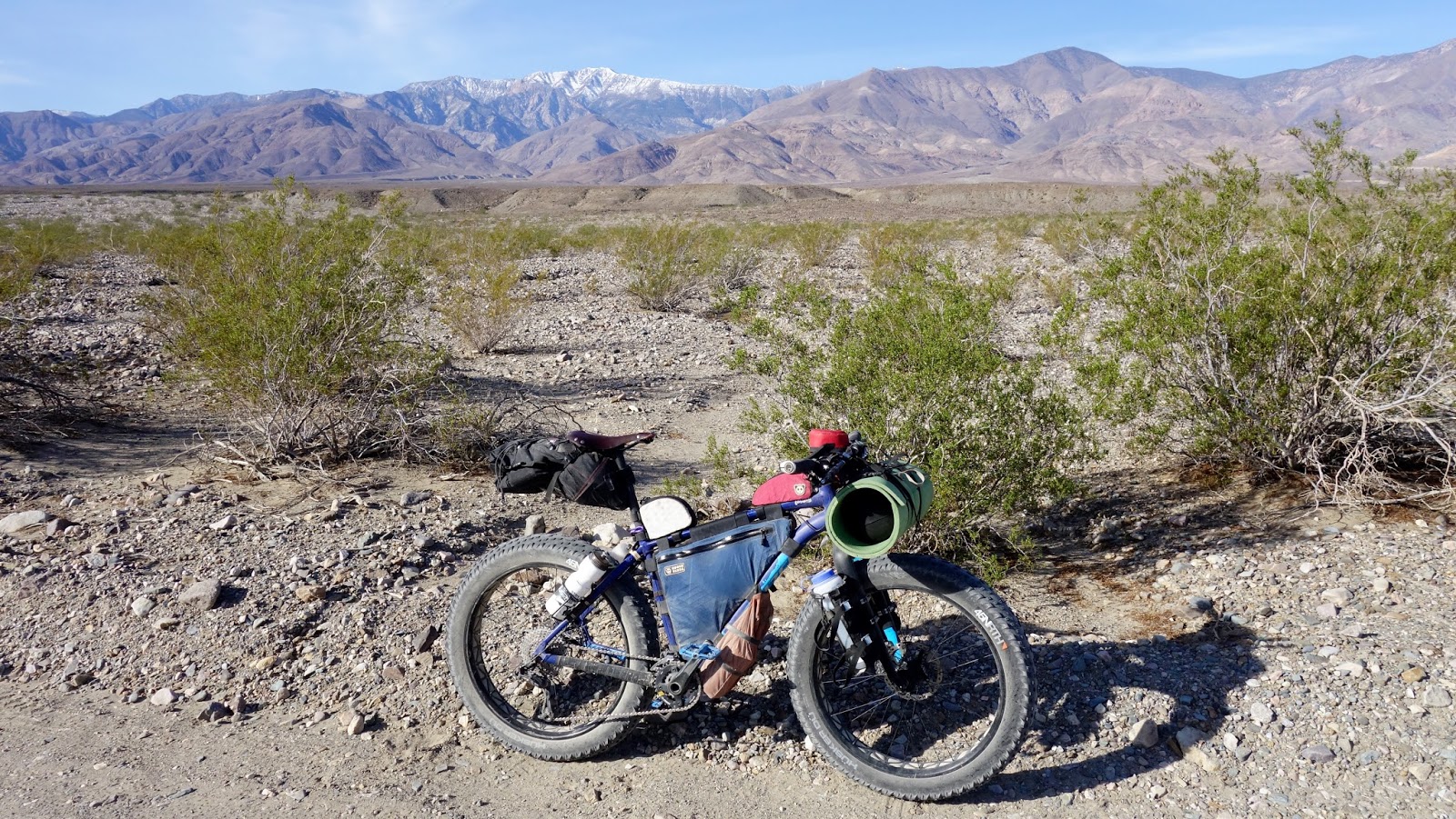
This was a really fun point to point ride and nearly all rideable. The availability of water makes the logistics much easier than typical long desert rides. I was quite happy with my 4" tires on 90mm rims but the route would also accommodate 3" plus sized tires. Due to sections of sand and loose gravel, going narrower although possible would seem to skew the fun/work ratio the wrong way. I highly recommend the route to anyone with a hankering for a fun bikepacking route. It could also be done as a day ride for those hammerheads out there. 87 miles with around 4200 ft. of climbing and 5200 ft descending. The elevation gain/loss is off a little though, I think there is several hundred more feet both climbing and descending.
Cheers!
 |
| Packing up camp on Johnson Cyn. rd. |
 |
| Telescope Peak |
 |
| Shorty Harris |