September 2023
Maps do funny things. They sometimes call out the most obscure place names...for no logical reason. I've run across several in my bike travels, Andy's Place near the Oregon Border in the Sheldon National Wildlife Refuge always comes to mind as an example. They always pique my curiosity spurring a visit. Such seems to be the case for Pizona California.
I chose this route for several reasons. I wanted to recon the portion that I would use were I to do a longer route heading south. But I needed to loop it this time so I routed across the Excelsior mountains which took me through Pizona. This was a 5 day route with day 3 being the most demanding, and it was also the day going through the place name of Pizona.
Day1. Pretty easy day really. I didn't even leave the house particularly early and didn't start riding until about 11am. Today was just an easy cruise out to Fletcher Spring, fill up with water and ride out further until below the first big climb over the Wassuk Range. I did see a group of Pronghorn on my way out to Fletcher. I could have ridden out to Fletcher from my house but that would've added 3 days one way to the ride. Here is the report for that ride.


 |
| Fletcher |


Day 2. Today was going to be a long day but not the hardest day. I made relatively short work of the climb up over the Wassuk range and rolled quickly down into Whiskey Flat. A car passed as I crossed over the pavement of hwy NV 359 as it continues south from Hawthorne. I could see the somewhat incredulous looks of the vehicles occupants as they whizzed past me in what would seem to be the 'middle of nowhere.' I crossed the valley and it's lone ranch outpost and began the second climb of the day up to Rattlesnake flat. It wasn't a long climb up to the valley and I intersected a route I had done in April of this same year upon arrival. It heralded the beginning of another climb up into the Excelsior Mountains and Summit Spring where I planned on filtering additional water. The water was much greener and 'full of life' than it had been back in April but it filtered out just fine. After filtering I continued on via a track I had ridden in April until I came to a junction where my old track veered right but my current route continued left down a canyon. This route yielded excellent adventure riding with no trace of the road that had once followed this route. I rolled down mini dryfalls and walked a couple that were not as mini. Loose decomposed granite over a firmer base demanded attention, a behaviour I learned the hard way when I took a complete digger and nearly did a couple of additional times. Finally nearing the flats of the valley floor above Teels Marsh and the old mining town of Marrietta, I stopped to take a break in the shade and internally debated my strategy for the remainder of the day. I briefly thought about camping right there but that would make for a long day tomorrow. I thought about waiting an hour or 2 for cooler temps going around Teels Marsh. Ultimately I just cooled off for 30-45 minutes in the shade of the canyon wall and continued on. I ran out of wash to ride in the lowest section before Marrietta and ended up just picking my way across the desert until I intersected the road that I knew was there. From there it was relatively quick riding until well out past Marrietta. I turned off and climbed the last couple of miles up to German Spring. Arriving there I was crushed to see the springs in pretty bad shape from the wild burros. I found a place to set up my camp then wandered around for over half an hour trying to find a reasonable water source to filter from. The water is abundandant but it has all been trampled and muddied by the burro's. I finally settled on attempting to retrieve water from a vertically placed 6" PVC pipe that was embedded in one muddy hole. I used my dip bag to dip water out of it and ran it through a bandana before putting it in my dirty bag for filtering. I retrieved enough water for the evening this way and left the pipe hoping the water level within would recover during the night for dipping more water in the morning. The donkey braying seemed to subside a bit with the onset of darkness and I was able to get some sleep with the help of ear plugs.


 |
| Summit spring |


 |
| German Spring with the pipe that I obtained water from |
 |
| Residents |
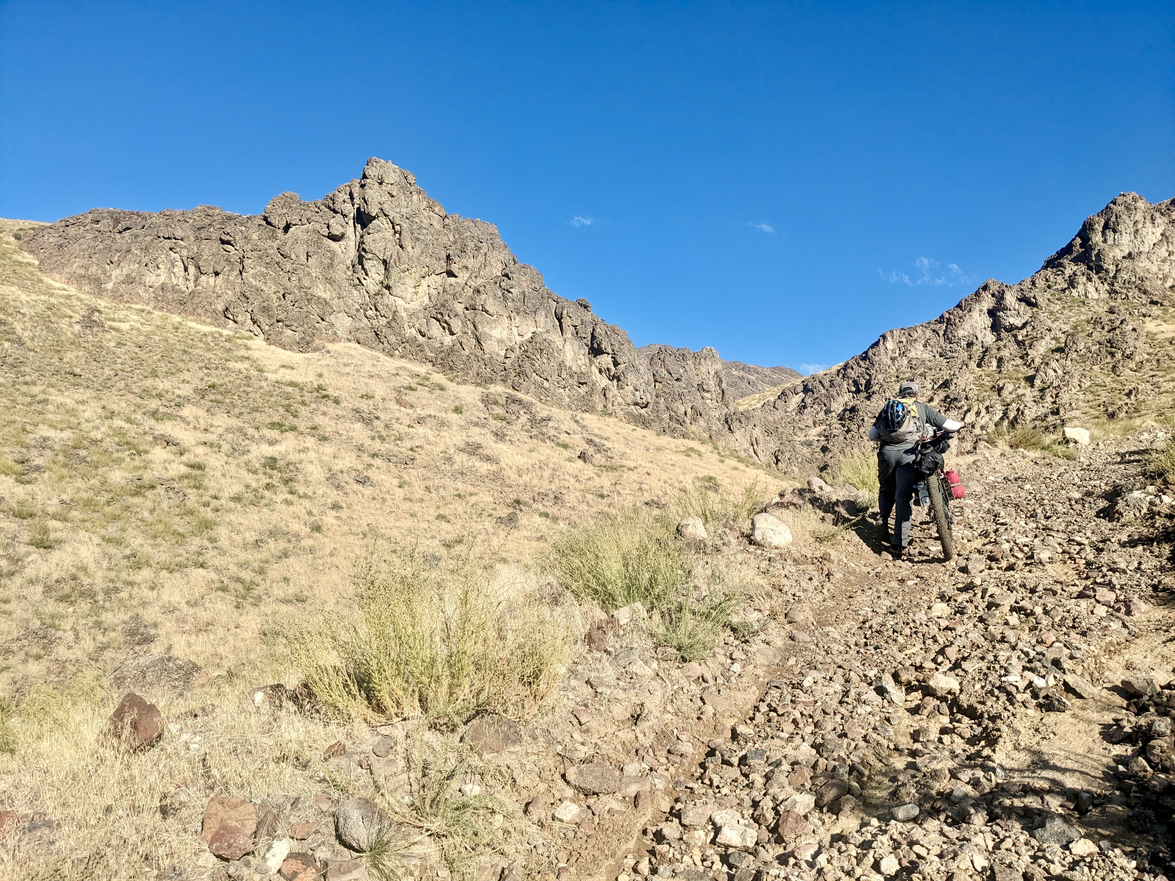
Day 3. Crack of dawn, or maybe sooner? and the burro's started up with the braying as they came in to drink from the main springs pool. Absolutely no sleeping after that. I got up and went to retrieve more water for filtering but the pipe had not recovered it's level. I dipped as much as I could reach which really was just enough. Packing up, the days riding began somewhat benign. As I climbed ever higher into the mountains the track just became rougher and rougher until I was just climbing up loose softball sized cobble. It was very difficult riding and went on for miles. The only respite was when the track turned to unrideably soft sand. The riding continued like this for around 14 miles until shortly before Sagehen Spring. The spring contained water and would be filterable if needed. I declined to filter any expecting easier riding all the way to Pizona Spring. Wrong! I passed McBride Spring and continued on. My GPS track took me on an overgrown and quite rowdy descent through a shallow draw before regaining better track. Then a short distance above Upper Pizona Spring the GPS track I was following completely disappeared on the actual ground. I noticed the ATV trail continued quite steeply up the hill while my GPS wanted me to drop into the wash. I rode up the ATV track a short distance but was fooled into thinking it climbed out of the drainage without dropping back to the wash. Turning back down to the wash I proceeded a until the brush became completely impenetrable with a bike. Climbing out the north side I tried following a horse trail. I gave up and pondered what to do. I scoped the surroundings as best I could then plunged back into the brush without my bike now heading south toward a faint line on the hillside that I hoped was the ATV track. It wasn't. But I did stumble across the track much lower near the wash. As it turned out the ATV track had climbed up a ways then split and a branch did indeed drop back into the wash, but I couldn't see that branch. Returning to retrieve my bike then thrashing back through the brush, I was mightily relieved to be on a track. More adventure riding took me continually down canyon until I finally did arrive at Pizona. I had found it! Another map waypoint mystery solved! I stopped and took a much needed physical and psychological break. It was getting late as travel had been quite slow today so I didn't spend any time looking for old ruins. I gathered myself together determined to make it down to River Spring.


 |
| Old structure on route |
 |
| Upper Pizona Spring |
 |
| Pizona |

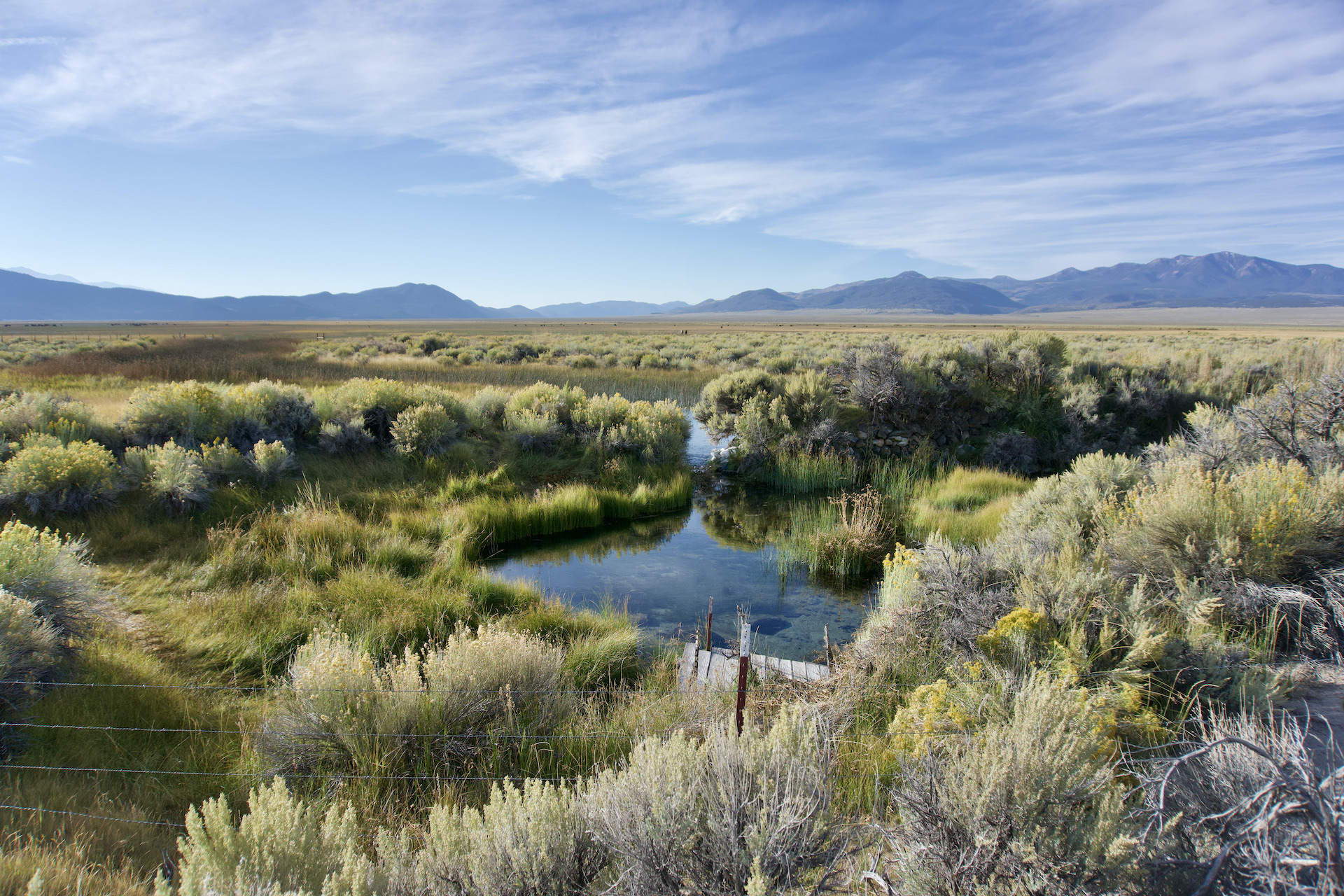
 |
| Beautiful River Spring |
Day 4. River Spring. Beautiful clear water bubbling up through the sand. The source is so obviously pure that after the first litre I didn't bother continuing to filter the water. I was out of water on arrival the night before but had filtered enough to get through the night. In the morning I just loaded up my normal amount plus a couple additional litres. Today I was crossing the Mono Lake basin and heading up to Bodie Ghost Town. The first few miles went well and then more sand. I made it across to to the good Dobie Meadows road after crossing a creek outflow that had some nice trout in it. I was now on the Caldera 500 bikepacking route and would follow it all the way to Bodie. I crossed hwy 167 following a pretty good road but about 3 miles in the route veered off onto yet another barely there 2 track. Sand, deep soft sand was my companion once again. The progress slowed and I heated up using more and more water. I stopped in the shade for about 30 minutes. I felt like I had to continue making progress so pushed on again. I only went about a half mile before I made the strategic decision to stop for the day. I was using too much water and would run out if I continued, plus, if I went any higher I could see the hillsides steepening and I didn't think I'd find a campsite. I set up camp and just enjoyed the spectacular view the remainder of the afternoon.

 |
| HA! Some of the best road on route! |


Day 5. The finish. It had turned out to be a great choice to stop the night before. In the morning it was cooler and although I still pushed my bike for a couple of miles, I made good progress, had plenty of water and the higher reaches of the route proved rideable all the way into Bodie. The state park entrance was manned but he let me through for no charge after I explained I was just passing through and out the other side. I've been to Bodie several times and even participated in a mountain bike not-race, race, a few years ago. I only stopped to refill my water in the bathrooms and then moved on. Bodie Canyon was next. I was no longer on the Caldera route and I knew that technically the road down through Bodie canyon was closed. This road is very subject to washouts and still near town I passed a road crew working on the road and grading. I had no idea if I could even get through the canyon. The upper reaches of the canyon weren't bad with only a couple of washed out creek crossings. But once past the old stateline toll house it got serious. I spent the next several hours alternately wading through the creek and working down through dry washout boulder gardens. So beautiful, but so slow, so tedious! Of course in due time I made it through the canyon and a quick downhill put me back at idyllic Fletcher Springs. I only had 14 miles back to my truck retracing the route I had ridden to get here a few days earlier. So after a nice cool off in the shade of the large Cottonwoods I ventured out into the hot sun and with no further incidents found myself back at the truck in about an hour and a half. Cracking a European beer, (I say European because don't they drink warm beer?) I leisurely broke down my gear and stowed it away, then began the fairly short drive home.


 |
| The Way |
 |
| Also the Way |


This link goes to the planned route as my ride didn't record properly on Ride With GPS. Please read the notes attached to the route page if you'd like to ride this yourself.
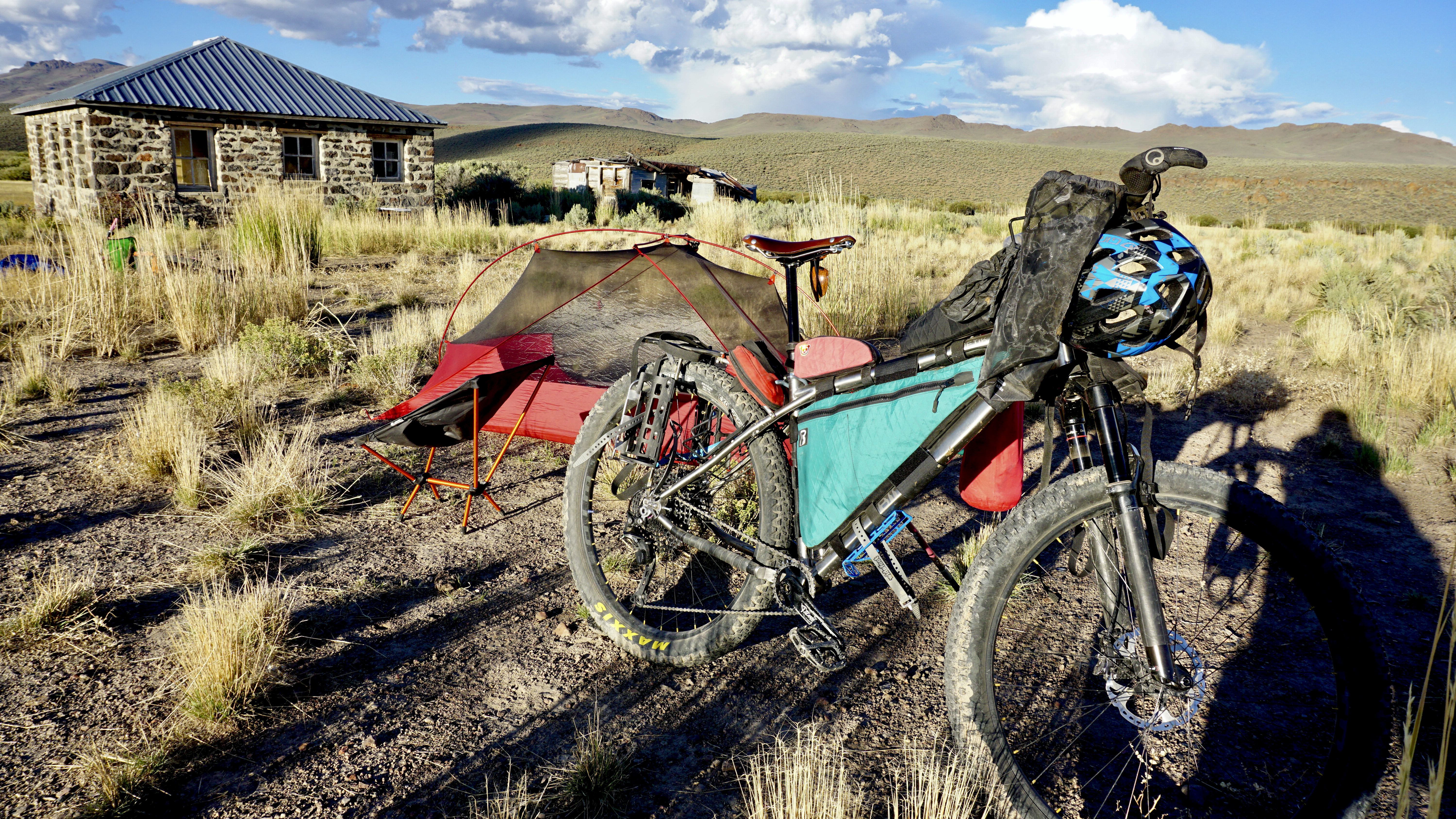
Bike setup: Binary Bicycles Kinetik running 29x3.0 tires. Front suspension, custom rack and bikepacking bags.
158.78 mi, 12,589 ft climbing