October 2024
It started in late fall 2023 when I accidentally discovered the word 'kiln" while browsing Google Earth in USGS topographic map overlay mode loosely looking for an interesting bikepacking area. I don't remember where I saw it first but the more I looked the more I found. Immediately the plan to bikepack to these sites formed in my mind and the Dark Sky's bikepacking route was conceived.
As winter progressed I continued to build the route and included petroglyphs and old stage stations whenever and wherever possible. Eventually I had something that looked feasible, now I had to find likely spots for water and resupply points for a trip that was substantially longer than any bikepacking trip I had done to date. The route slowly filled in and by spring I had what to me looked like a good route with reasonable resupply and water. Of course in the desert you never really know if you'll find water where you planned until you arrive. Many of the places I had marked were dry but we always found enough to proceed forward.
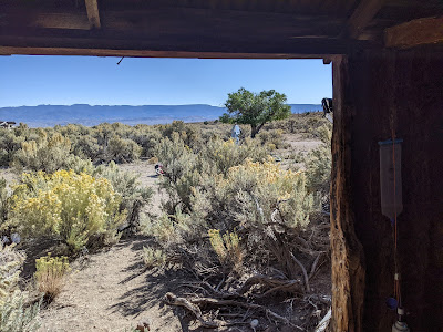 |
| Clear Creek Ranch. Our apple tree in background. |
Spring came and Joannie and I went on a month long road trip to Alaska. That closed the door for riding this route until at least fall. By then Kurstin (check out his blog site) had come on board again and was all in. In fact after our Sagebrush Ripple outing in October 2023 he had a like mindset and had ridden parts of what became Dark Sky's in November 2023, shortly after Sagebrush Ripple.
 |
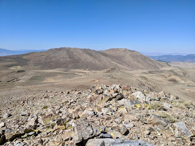
| Top of the 'Tybo Push' |
 | |||
| Kiln in Kiln Canyon |
 |
| Pritchard's station |
Some of the highlights of our journey were of course the many charcoal kiln's we visited, the hard push up kiln canyon and over the crest to Tybo semi-ghost town. Semi because there are a couple hardy folks still living there. The rock art panels near Moore's (old) stage station. The remains of Pritchard's stage station. The evening of day 5 after a long ride to a camp just outside of Currant, we enjoyed a showing of comet C/2023 A3 (Tsuchinshan-ATLAS) Kurstin was able to capture an image of it. We saw it again from Cave Lake State Park. Day 6 we made it to All In One Truck Stop. A delightful chance to get a room, clean up, resupply and eat in the cafe. Speaking for myself, I needed it, I was a filthy, sweaty mess of a bikepacker! And the mountains! Hot Creek Range, Egan Range, Schell Creek Range. Each range we crossed seemed determined to outdo the last with it's own spectacular scenery. The high point in elevation came at Kalamazoo Pass at just under 9000 ft after climbing up a beautiful canyon next to a creek and adorned with eye popping fall colors. Crossing the White Pine Range we detoured up to Shermantown. Shermantown was where the milling was done for the surrounding mining districts. Then it was down through Cathedral Canyon with shear cliffs hundreds feet high and at least 2 natural arches in the towering limestone. Green Springs was a critical water supply. I must have really liked it because I got up close and personal with it when I took a face plant into a mucky soggy field. But what a beautiful oasis in the desert!
 |
| See the comet? Photo by Kurstin. |
 |
| Incredible Charcoal Kiln's in South Sixmile canyon |
 |
| The 'Stone Cabin' |
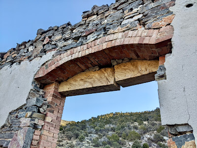 |
| Sandstone lintel in Shermantown |
 |
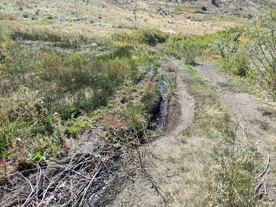
| Green Sprgs. Photo by Kurstin |
We had a wildly successful trip with good if somewhat warm weather, no mechanicals, no illness or injuries. Kurstin is a great partner and has an endless supply of stoke.
Photos: I've only uploaded a very few photos into the body of this blog post. For daily albums click here. (Day 10 was our hotel rest day and day 15 I neglected to take any photos.) Also check out my instagram for photos, @seeker57 and Kurstin's instagram @bikepackingnv
Kurstin's daily notes:
Dark Sky’s Route - Daily Notes
Day 1 Out of Eureka - Good roads, climb was a hike-a-bike. Descended a killer area with Juniper, big boulders. Nice camping. Cross a valley. Old ranch. Climb to camp, past spring/meadow.
Yahoo Canyon between Mahogany Hills and Mountain Boy Range - Spring Valley - Antelope Valley between Monitor Range and Fish Creek Range - climbed into Antelope Range at the end of Valley, passed Dick Allison Spring to camp.
Day 2 - Long descent to Clear Creek, old apple tree. Net descent day into Little Fish Lake Valley. Through canyon above Hot Creek Canyon. Climb to camp, selected pinyons for shade. Hot afternoons.
Dry Valley between Monitor and Antelope Ranges - dropped into Little Fish Lake Valley between Monitor and Hot Creek Ranges - 3 “lakes” - Box Canyon - camped just beyond McIntyre Summit
Day 3 Descend to Tybo-Push - Kilns, long hike-a-bike. But spectacular. More Kilns over the top. Descend to Tybo, no water. Cross the contaminated site. Rolling descent to Hot Creek Ranch. Filtered Hot Creek water, kinda gross tasting. Climb to 6 Mile, enter 6 Mile, lots of intermittent water, shallow creek crossings. Fish! Kilns, then Kilns + camp.
Stone Cabin Valley then turned into Hot Creek Range - Hike-a-bike Kiln Canyon - over the top into Cottonwood Canyon following Tybo Creek to Tybo - Hot Creek Valley - turned into Sixmile Canyon - 3 miles in to camp at kilns at the base of Charcoal Canyon
Day 4 - Good road then long hike-a-bike to top of Six Mile South. Spring just over the top. Great aspens. Wild descent, steep and sandy. Tricky. Couple more climbs. Drop down to Moore’s Station, side trip to petroglyphs. Met a nice couple from Strawberry, CA on their way to S. Utah. They gave us water. Rode on to Pritchard’s Station. Decided to camp where there is water. Big Water Carries, next two days.
Into the Hot Creek Range - South Sixmile Canyon to Sixmile Summit to North Sixmile Canyon - exit to Moores Station - Petroglyphs at Petroglyph Butte - climb Moores Station Wash - Pritchards Station, Pritchards Canyon
Day 5 - Left Pritchard’s for Summit Station. Then onto Brown’s Reservoir. Everything was dry. Cattle are for the most part off the range, troughs are empty. Climbed above Duckwater Reservation, after a little re-route. Saved us a long sandy hike-a-bike. Then a great descent through a canyon on Rez. Found water just outside of Rez residential area. Road through to Highway, took pavement to Currant. It was Railroad Valley Days at community center. It was late, we were smelly, we rode onto camp. Entertained by locals passing by. Comet sighting.
Pritchards Canyon between Park Range and Andesite Ridge - Summit Station - Little Smoky Valley - Big Sand Springs Valley - Pancake Range - Duckwater Valley - Duckwater Hills - Railroad Valley - Grant Range
Day 6 Currant to Preston - Climb and good descent into a long hot valley. Consumed a lot of water 5.5L and was pretty parched by time we made it to Lund/Preston. The All-In-One, Motel, RV Park, Truck Stop, Convenience Store, Showers, Restaurant was pretty awesome! My body couldn’t figure out what was going on, shower, beer, dinner, snacks, water, Power Ade. Sleeping in a bed.
Grant Range to Horse Range - Stone Cabin - The Cove, White River Valley - Preston/Lund
Day 7 (Monday 14th) Storm forecasted for Thursday 17th. That day we were to cross the highest point on the route, ~ 9k’. So we decided on a re-route. After a restaurant pancake and motel room coffee we were off for a 3k’ climb up Sawmill Canyon. Another highlight climb. Future sport climbing crag thanks to Vince, a relocated Bay Area climbing bum. Summit at 8500’ where I am writing this! Pinyon-Juniper has given way to White Pine and Mahogany. Great descent into the never ending Steptoe Valley. Climb to Elk Flat Campground. 48 miles, 4000’ climbing.
White River Valley - Sawmill Canyon, Egan Range - Lone Pine Summit - Lone Pine Swale - Steptoe Valley - Comins Lake - Schell Creek Range
Day 8 Outta Cave Lake - Big climb through limestone formations and aspens. Chatted with 2 rangers. Must see’s Hunt Unit 241 or 121, ghost town just below camp, Cave Overlook Trail. Crested pass about 2 hours in, 8698’. Re-route in progress to avoid storm on Thursday. Descent was fun, lots of rock formations but not as big. Slightly technical. Hit SR 893, 35 ish miles. Ranches vs. Schell Range. So much water. Turn at Kalamazoo Creek. Long day, very little traffic, pronghorn, lizards, snakes, jackrabbit, sage grouse, raven, fish. Has potential to return.
Cave Creek Reservoir - Cooper Canyon - Cooper Summit - Spring Valley - SR 893 - Cleve Creek Campground - Kalamazoo
Day 9 Climb Kalamazoo - 3200’ off the deck! Climbing along creek. Dominated by aspens and white pine and mahogany. Nice campsites 3 miles in. Picnic tables, vault toilet (fly trap). Road is well maintained. Summit just below 9k’ is super windy, no kidding. Climb was moderate to steep, ~400’/mile. Looks like a long downhill to McGill, then 10 miles to Ely. Downhill but headwind! Stopped for Cokes, then onto Hwy 93. Frontage Rd (intermittent) didn’t seem worth it. Nice shoulder. Arriving in Ely got a recommendation from Kyle Horvath for the Four Sevens Motel. The de facto bike motel. Good location. Ate at Racks. Met with Kyle.
All Kalamazoo - descend along North Creek - through Gallagher Gap between Schell Creek Range and Duck Creek Range - Steptoe Valley
Day 10 Rest Day.
Day 11 - Leaving Ely in the cold overcast morning. What a change, 29*F, high of 48*F. Its been in the 70’s-80’s. Ward Mtn Summit was 32*F. Got off the highway for a great little road through the P&J forest. 25 ish mile downhill with a tailwind into Preston. Another close encounter with pronghorn. Wind at 23 mph in Preston. Rather than turning into it we stayed another night. Ha!
Egan Range - Murray Canyon - Murray Summit - Ward Mountain - White River Valley - Preston
Day 12 - Wind dropped to 12 mph. Took a couple of tries to get out of Preston. It took 15 miles to get to public land and 17 miles to get where we would have camped. Pretty much climbing all day, beautiful canyons. Lots of water. Signage for National Discovery Trail. Next stop Shermantown. Camped at the bottom of the road to Shermantown. Watched a truck pulling a horse trailer down a loose 15% grade. Horse and dog. Two motos and a Tacoma came down from S-town.
White Pine Range - another Sixmile Wash - Cathedral Canyon - Eberhardt - Shermantown Canyon
Day 13 - Woke to 35* but temps dropped to 30* while packing. S-town was a great set of ruins in a fun little cyn. Definitely worth it. Next was Cathedral Cyn, WOW! Caves, arches, rock prows. Hike-a-bike following a cow path. Well worth it. Rolling P-J forest to early camp off Duckwater Valley Rd. Busy desert road. Nice camp, deer came through the night. Mild temps, woke to 38*
Shermantown Cyn - Cathedral Cyn - Green Springs - Railroad Valley - Pancake Range
Day 14 - Found a great well at Pogues stage stop. Then across the cold Fish Creek Valley to Fish Creek Ranch. Climbed the range, good road, stout grade. Traverse across to springs, find camp. Springs all locked up by private ranches. Creek flowing under road so no problem finding water. Camped off Craig’s road in the junipers. Nice spot. Short day tomorrow.
Little Smoky Valley - Pogues Station - Fish Creek Valley - Fish Creek Range - Fenstermaker Wash - 3 C Well (ranch) - Cerutti Well (solar) - Allison Creek (corral) - camped off Cedar Creek Rd, Monitor Range
Day 15 - Rolling north to Hwy 50. Passed Hot Springs Ranch, a potential commercial retreat? Turning onto 50, considerate drivers. Checked out a few side roads to north and south. Great meal at Middle Gate. Table next to us had a Monster Burger. Guy made it as far as I did once upon a time. Not far at all.
Antelope Valley - Yahoo Canyon
Doug's daily notes:
D1 Left truck DOT pit yard. 1 steep HAB. Beautiful rock formations, long dusty flats Wtr as it crosses rd near Segura Ranch. Camp 39.072993, -116.315260
D2 To mile 100. Wtr at Clear Cr. Little Fish Lk Valley. Box Cyn. Intersect Sagebrush Ripple. East Stone Cabin Valley. Scooter crash. Camp 38.434456, -116.517198
D3 Kiln cyn. Hard push over Tybo. Tech downhill to Tybo. Wtr at Hot Creek. S. sixmile cyn to 2nd Kilns. Water in creek. Some pushing and sandy slow. Camp 38.592803, -116.326611
D4 Push, over S. sixmile pass 8.7k. Pristine Kilns. Additional kiln's in Woodtick cyn. No Morey Pk. To Pritchards. Pets @ Moore's. Given wtr at pets. Camp at Pritchard's. Wtr at camp. Camp 38.777618, -116.175828
D5 Pritchard's To Currant. Summit station. Reroute at Brown's Reservoir. Duckwater, filter. Railroad valley Days. No wtr till Preston. Comet!! Camp 38.725938, -115.457531
D6 Currant to Preston. Stone cabin, Washout cut bank. Ragged Ridge, Red Mtn Cross Horse Range. Sand. Camp All in one Truck stop motel.
D7 Preston to Cave Lk SP. Across Egan range via Sawmill cyn, Vince, Lone Pine pass to Steptoe Valley. Hole in the bank spring flowing. Kurstin found a road coke. Comet!! Camp Elk Flat CG, 39.187201, -114.718143
D8 Cave Lk to Kalamazoo. Spring Valley. Schell Creek Range. Cooper summit 8.6k. Reroute for weather. Multiple creeks on reroute. Camp 39.575168, -114.536783
D9 Kalamazoo to Ely. Kalamazoo cyn and Pass. 8.9k high pt. Lots of color in trees. Pony Express mural in McGill. Four Seven's motel. Racks bar & grill.
D10 Additional night in Ely. Chat with Kyle. Racks bar & grill.
D11 A dash of snow. Hard tailwind to Lund. Stayed at motel
D12 Preston to camp below Sherman town. Headwind, Willow grove wtr. White Pine range, Ellison creek. Washburn's stage station, Diet Pepsi from ATV'er. Lots of water high, not just Tom Plain sprg. Lots of horse sign. Englehardt. Camp 39.179800, -115.489955
D13 Up to Sherman Town. Cool tooled cut sandstone. Cathedral cyn. Green sprgs, fell in mud. Camp above Pogue's. Cool rolling territory. Camp, 39.165733, -115.850230
D14 Sherman junc to random camp. Kurstin found well at Pogue's. Sullivan fenced off but wtr in Allison creek. Cramp. Road Grader. Camp 39.363756, -116.360706
D15 Easy day back to truck. Hot Sprg Ranch. Road grader. Middlegate burgers.


